
- THE EVENT
The Event
The International CAE Conference is one of the most important appointments for Computational and Simulation Technologies
Read more..Venue
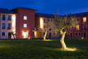
The event will take place in Pacengo - Lazise (VR) at the Hotel Parchi del Garda Read more..
Past Editions
This edition will be the 29th anniversary of the International CAE Conference
Read more.. - PAPER
Submit a Paper
The 29th International CAE Conference represents a great opportunity to disseminate your R&D results, to stimulate discussion and share knowledge.
- PROGRAM
Conference Program
Build your personal Conference plan choosing among different talks, technology updates and industrial sessions. Meet experts, opinion leaders and join the open discussion within the widest analysts community.
- EXHIBITION
Sponsor of the Event
Get the best opportunity to promote your expertise, technology and company among the International CAE Conference Community.
- PROCEEDINGS
Proceedings
2013 CAE Conference Proceedings are now available to download from: proceedings2013.caeconference.com
- NEWS
News & Highlights
Check here for the latest news and information about International CAE Conference.
Read more.. - PRESS AREA
Press Area
Photos, videos, press kit and press releases.
Read more.. - POSTER AWARD
Poster Award
This contest is open to students, graduate students, researches, and / or teachers from universities and Research Centers. Participation is free.
High-precision mobile and airborne survey
Augusto Burchi
SITECO
Complete mobile mapping survey of a 15 km motorway stretch, combined with an airborne Lidar survey. Both surveys have been inserted in a consistent geodetical frame by means of a polygonal of Ground Control Points. The final deliveries include the maps in scale 1:500 and the Digital Terrain Model, to be used for the executive design of a new intersection.

International CAE Conference - Infoline
info@caeconference.com - Ph. +39 0461 979 474
© All rights reserved